

利用 Google 地圖建立基準,讓 Gemini 的生成式功能連結至 Google 地圖豐富、真實且最新的資料。這項功能可讓開發人員輕鬆將位置資訊感知功能整合至應用程式。如果使用者查詢的內容與地圖資料相關,Gemini 模型會利用 Google 地圖提供準確且即時的答案,並與使用者指定的所在位置或一般區域相關。
- 準確的地理位置感知回覆:針對特定地理位置的查詢,運用 Google 地圖豐富且最新的資料。
- 強化個人化功能:根據使用者提供的所在位置,量身打造推薦內容和資訊。
開始使用
本範例說明如何將 Grounding with Google Maps 整合至應用程式,根據使用者查詢提供準確的回覆,並加入位置資訊。提示會要求提供當地建議,並可選用使用者位置資訊,讓 Gemini 模型使用 Google 地圖資料。
Python
from google import genai
from google.genai import types

client = genai.Client()

prompt = "What are the best Italian restaurants within a 15-minute walk from here?"

response = client.models.generate_content(
    model='gemini-3.8-flash',
    contents=prompt,
    config=types.GenerateContentConfig(
        # Turn on grounding with Google Maps
        tools=[types.Tool(google_maps=types.GoogleMaps())],
        # Optionally provide the relevant location context (this is in Los Angeles)
        tool_config=types.ToolConfig(retrieval_config=types.RetrievalConfig(
            lat_lng=types.LatLng(
                latitude=34.050481, longitude=-118.248526))),
    ),
)

print("Generated Response:")
print(response.text)

if grounding := response.candidates[0].grounding_metadata:
  if grounding.grounding_chunks:
    print('-' * 40)
    print("Sources:")
    for chunk in grounding.grounding_chunks:
      print(f'- [{chunk.maps.title}]({chunk.maps.uri})')
JavaScript
import { GoogleGenAI } from "@google/genai";

const ai = new GoogleGenAI({});

async function generateContentWithMapsGrounding() {
  const response = await ai.models.generateContent({
    model: "gemini-3.8-flash",
    contents: "What are the best Italian restaurants within a 15-minute walk from here?",
    config: {
      // Turn on grounding with Google Maps
      tools: [{ googleMaps: {} }],
      toolConfig: {
        retrievalConfig: {
          // Optionally provide the relevant location context (this is in Los Angeles)
          latLng: {
            latitude: 34.050481,
            longitude: -118.248526,
          },
        },
      },
    },
  });

  console.log("Generated Response:");
  console.log(response.text);

  const grounding = response.candidates[0]?.groundingMetadata;
  if (grounding?.groundingChunks) {
    console.log("-".repeat(40));
    console.log("Sources:");
    for (const chunk of grounding.groundingChunks) {
      if (chunk.maps) {
        console.log(`- [${chunk.maps.title}](${chunk.maps.uri})`);
      }
    }
  }
}

generateContentWithMapsGrounding();
REST
curl -X POST 'https://generativelanguage.googleapis.com/v1beta/models/gemini-3.8-flash:generateContent' \
  -H 'Content-Type: application/json' \
  -H "x-goog-api-key: ${GEMINI_API_KEY}" \
  -d '{
  "contents": [{
    "role": "user",
    "parts": [{
      "text": "What are the best Italian restaurants within a 15-minute walk from here?"
    }]
  }],
  "tools": [{"googleMaps": {}}],
  "toolConfig": {
    "retrievalConfig": {
      "latLng": {"latitude": 34.050481, "longitude": -118.248526}
    }
  }
}'
如何利用 Google 地圖建立基準
利用 Google 地圖建立基準的服務會使用 Maps API 做為基準來源,將 Gemini API 與 Google 地理位置生態系統整合。如果使用者查詢包含地理位置背景資訊,Gemini 模型可以叫用「以 Google 地圖建立基準」工具。模型接著就能根據與所提供位置相關的 Google 地圖資料,生成回覆。
整個程序通常涵蓋下列工作:
- 使用者查詢:使用者向應用程式提交查詢,可能包含地理位置資訊 (例如「附近的咖啡店」、「舊金山的博物館」)。
- 工具呼叫:Gemini 模型辨識出地理意圖後,會呼叫「利用 Google 地圖建立基準」工具。這項工具可選擇性提供使用者的
latitude和longitude。這項工具是文字搜尋工具,運作方式與在 Google 地圖上搜尋類似,也就是說,本地查詢 (「附近的」) 會使用座標,而特定或非本地查詢則不太可能受到明確位置的影響。 - 資料擷取:「利用 Google 地圖建立基準」服務會查詢 Google 地圖,找出相關資訊 (例如地點、評論、相片、地址、營業時間)。
- 以資料為基準生成內容:系統會使用擷取的 Maps 資料,做為 Gemini 模型回覆的依據,確保內容符合事實且具關聯性。
- 回覆:模型會傳回文字回覆,其中包含 Google 地圖來源的引用內容。
使用 Google 地圖建立基準的原因和時機
如果應用程式需要準確、最新且特定地點的資訊,就非常適合使用「利用 Google 地圖建立基準」功能。這項功能會根據 Google 地圖全球超過 2.5 億個地點的龐大資料庫,提供相關且個人化的內容,提升使用者體驗。
如果應用程式需要執行下列操作,請使用「利用 Google 地圖建立基準」功能:
- 完整且如實回答特定地區的問題。
- 打造對話式旅遊行程規劃工具和當地導覽。
- 根據位置和使用者偏好 (例如餐廳或商店) 推薦搜尋點。
- 為社群、零售或外送服務打造位置感知體驗。
在需要鄰近地區和當前事實資料的應用情境中,例如尋找「我附近最好的咖啡店」或取得路線指引,Google 地圖基礎模型表現優異。
API 方法和參數
透過 Gemini API,您可以使用 generateContent 方法,將 Google 地圖做為工具建立基準。如要啟用及設定利用 Google 地圖建立基準,請在要求的 tools 參數中加入 googleMaps 物件。
JSON
{
  "contents": [{
    "parts": [
      {"text": "Restaurants near Times Square."}
    ]
  }],
  "tools":  { "googleMaps": {} }
}
此外,這項工具也支援將情境位置資訊做為 toolConfig 傳遞。
JSON
{
  "contents": [{
    "parts": [
      {"text": "Restaurants near here."}
    ]
  }],
  "tools":  { "googleMaps": {} },
  "toolConfig":  {
    "retrievalConfig": {
      "latLng": {
        "latitude": 40.758896,
        "longitude": -73.985130
      }
    }
  }
}
瞭解基礎回應
如果系統成功以 Google 地圖資料為回覆內容的依據,回覆就會包含 groundingMetadata 欄位。這類結構化資料對於驗證聲明、在應用程式中建立豐富的引用體驗,以及符合服務使用規定至關重要。
JSON
{
  "candidates": [
    {
      "content": {
        "parts": [
          {
            "text": "CanteenM is an American restaurant with..."
          }
        ],
        "role": "model"
      },
      "groundingMetadata": {
        "groundingChunks": [
          {
            "maps": {
              "uri": "https://maps.google.com/?cid=13100894621228039586",
              "title": "Heaven on 7th Marketplace",
              "placeId": "places/ChIJ0-zA1vBZwokRon0fGj-6z7U"
            },
            // repeated ...
          }
        ],
        "groundingSupports": [
          {
            "segment": {
              "startIndex": 0,
              "endIndex": 79,
              "text": "CanteenM is an American restaurant with a 4.6-star rating and is open 24 hours."
            },
            "groundingChunkIndices": [0]
          },
          // repeated ...
        ],
        "webSearchQueries": [
          "restaurants near me"
        ]
      }
    }
  ]
}
Gemini API 會傳回下列資訊:
groundingMetadata:
groundingChunks:包含maps來源 (uri、placeId和title) 的物件陣列。groundingSupports:要將模型回應文字連結至groundingChunks中來源的區塊陣列。每個區塊都會將文字範圍 (由startIndex和endIndex定義) 連結至一或多個groundingChunkIndices。這是建構內文引文的關鍵。
如需顯示如何以文字呈現文內引用的程式碼片段,請參閱「以 Google 搜尋強化事實基礎」文件中的範例。
用途
「利用 Google 地圖建立基準」功能支援多種與位置資訊相關的用途。以下範例說明如何透過不同的提示詞和參數,利用 Google 地圖建立基準。Google 地圖基礎結果中的資訊可能與實際情況不同。
處理地點相關問題
詳細詢問特定地點的問題,根據 Google 使用者評論和其他地圖資料取得解答。
Python
from google import genai
from google.genai import types

client = genai.Client()

prompt = "Is there a cafe near the corner of 1st and Main that has outdoor seating?"

response = client.models.generate_content(
    model='gemini-3.8-flash',
    contents=prompt,
    config=types.GenerateContentConfig(
        # Turn on the Maps tool
        tools=[types.Tool(google_maps=types.GoogleMaps())],

        # Provide the relevant location context (this is in Los Angeles)
        tool_config=types.ToolConfig(retrieval_config=types.RetrievalConfig(
            lat_lng=types.LatLng(
                latitude=34.050481, longitude=-118.248526))),
    ),
)

print("Generated Response:")
print(response.text)

if grounding := response.candidates[0].grounding_metadata:
  if chunks := grounding.grounding_chunks:
    print('-' * 40)
    print("Sources:")
    for chunk in chunks:
      print(f'- [{chunk.maps.title}]({chunk.maps.uri})')
  ```
JavaScript
import { GoogleGenAI } from '@google/genai';

const ai = new GoogleGenAI({});

async function run() {
  const prompt = "Is there a cafe near the corner of 1st and Main that has outdoor seating?";

  const response = await ai.models.generateContent({
    model: 'gemini-3.8-flash',
    contents: prompt,
    config: {
      // Turn on the Maps tool
      tools: [{googleMaps: {}}],
      // Provide the relevant location context (this is in Los Angeles)
      toolConfig: {
        retrievalConfig: {
          latLng: {
            latitude: 34.050481,
            longitude: -118.248526
          }
        }
      }
    },
  });

  console.log("Generated Response:");
  console.log(response.text);

  const chunks = response.candidates[0].groundingMetadata?.groundingChunks;
  if (chunks) {
    console.log('-'.repeat(40));
    console.log("Sources:");
    for (const chunk of chunks) {
      if (chunk.maps) {
        console.log(`- [${chunk.maps.title}](${chunk.maps.uri})`);
      }
    }
  }
}

run();
REST
curl -X POST 'https://generativelanguage.googleapis.com/v1beta/models/gemini-3.8-flash:generateContent' \
  -H 'Content-Type: application/json' \
  -H "x-goog-api-key: ${GEMINI_API_KEY}" \
  -d '{
  "contents": [{
    "role": "user",
    "parts": [{
      "text": "Is there a cafe near the corner of 1st and Main that has outdoor seating?"
    }]
  }],
  "tools": [{"googleMaps": {}}],
  "toolConfig": {
    "retrievalConfig": {
      "latLng": {"latitude": 34.050481, "longitude": -118.248526}
    }
  }
}'
提供以位置資訊為依據的個人化服務
根據使用者的偏好和特定地理區域提供建議。
Python
from google import genai
from google.genai import types

client = genai.Client()

prompt = "Which family-friendly restaurants near here have the best playground reviews?"

response = client.models.generate_content(
    model='gemini-3.8-flash',
    contents=prompt,
    config=types.GenerateContentConfig(
      tools=[types.Tool(google_maps=types.GoogleMaps())],
      tool_config=types.ToolConfig(retrieval_config=types.RetrievalConfig(
          # Provide the location as context; this is Austin, TX.
          lat_lng=types.LatLng(
              latitude=30.2672, longitude=-97.7431))),
    ),
)

print("Generated Response:")
print(response.text)

if grounding := response.candidates[0].grounding_metadata:
  if chunks := grounding.grounding_chunks:
    print('-' * 40)
    print("Sources:")
    for chunk in chunks:
      print(f'- [{chunk.maps.title}]({chunk.maps.uri})')
JavaScript
import { GoogleGenAI } from '@google/genai';

const ai = new GoogleGenAI({});

async function run() {
  const prompt = "Which family-friendly restaurants near here have the best playground reviews?";

  const response = await ai.models.generateContent({
    model: 'gemini-3.8-flash',
    contents: prompt,
    config: {
      tools: [{googleMaps: {}}],
      toolConfig: {
        retrievalConfig: {
          // Provide the location as context; this is Austin, TX.
          latLng: {
            latitude: 30.2672,
            longitude: -97.7431
          }
        }
      }
    },
  });

  console.log("Generated Response:");
  console.log(response.text);

  const chunks = response.candidates[0].groundingMetadata?.groundingChunks;
  if (chunks) {
    console.log('-'.repeat(40));
    console.log("Sources:");
    for (const chunk of chunks) {
      if (chunk.maps) {
        console.log(`- [${chunk.maps.title}](${chunk.maps.uri})`);
      }
    }
  }
}

run();
REST
curl -X POST 'https://generativelanguage.googleapis.com/v1beta/models/gemini-3.8-flash:generateContent' \
  -H 'Content-Type: application/json' \
  -H "x-goog-api-key: ${GEMINI_API_KEY}" \
  -d '{
  "contents": [{
    "role": "user",
    "parts": [{
      "text": "Which family-friendly restaurants near here have the best playground reviews?"
    }],
  }],
  "tools": [{"googleMaps": {}}],
  "toolConfig": {
    "retrievalConfig": {
      "latLng": {"latitude": 30.2672, "longitude": -97.7431}
    }
  }
}'
協助規劃行程
生成多日行程,提供路線資訊和各種地點的相關資訊,非常適合旅遊應用程式。
Python
from google import genai
from google.genai import types

client = genai.Client()

prompt = "Plan a day in San Francisco for me. I want to see the Golden Gate Bridge, visit a museum, and have a nice dinner."

response = client.models.generate_content(
    model='gemini-3.8-flash',
    contents=prompt,
    config=types.GenerateContentConfig(
      tools=[types.Tool(google_maps=types.GoogleMaps())],
      tool_config=types.ToolConfig(retrieval_config=types.RetrievalConfig(
          # Provide the location as context, this is in San Francisco.
          lat_lng=types.LatLng(
              latitude=37.78193, longitude=-122.40476))),
    ),
)

print("Generated Response:")
print(response.text)

if grounding := response.candidates[0].grounding_metadata:
  if grounding.grounding_chunks:
    print('-' * 40)
    print("Sources:")
    for chunk in grounding.grounding_chunks:
      print(f'- [{chunk.maps.title}]({chunk.maps.uri})')
JavaScript
import { GoogleGenAI } from '@google/genai';

const ai = new GoogleGenAI({});

async function run() {
  const prompt = "Plan a day in San Francisco for me. I want to see the Golden Gate Bridge, visit a museum, and have a nice dinner.";

  const response = await ai.models.generateContent({
    model: 'gemini-3.8-flash',
    contents: prompt,
    config: {
      tools: [{googleMaps: {}}],
      toolConfig: {
        retrievalConfig: {
          // Provide the location as context, this is in San Francisco.
          latLng: {
            latitude: 37.78193,
            longitude: -122.40476
          }
        }
      }
    },
  });

  console.log("Generated Response:");
  console.log(response.text);

  const groundingMetadata = response.candidates[0]?.groundingMetadata;
  if (groundingMetadata) {
    if (groundingMetadata.groundingChunks) {
      console.log('-'.repeat(40));
      console.log("Sources:");
      for (const chunk of groundingMetadata.groundingChunks) {
        if (chunk.maps) {
          console.log(`- [${chunk.maps.title}](${chunk.maps.uri})`);
        }
      }
    }
  }
}

run();
REST
curl -X POST 'https://generativelanguage.googleapis.com/v1beta/models/gemini-3.8-flash:generateContent' \
  -H 'Content-Type: application/json' \
  -H "x-goog-api-key: ${GEMINI_API_KEY}" \
  -d '{
  "contents": [{
    "role": "user",
    "parts": [{
      "text": "Plan a day in San Francisco for me. I want to see the Golden Gate Bridge, visit a museum, and have a nice dinner."
    }]
  }],
  "tools": [{"googleMaps": {}}],
  "toolConfig": {
    "retrievalConfig": {
    "latLng": {"latitude": 37.78193, "longitude": -122.40476}
  }
  }
}'
服務使用規定
本節說明使用「透過 Google 地圖定位」服務的相關規定。
告知使用者 Google 地圖來源的使用情形
每則 Google 地圖基礎結果都會附上來源,groundingChunks以佐證回覆內容。系統也會傳回下列中繼資料:
- 來源 URI
- title
- ID
呈現利用 Google 地圖建立基準的結果時,您必須指定相關聯的 Google 地圖來源,並告知使用者下列事項:
- Google 地圖來源必須緊接在來源支援的生成內容之後。這類生成內容也稱為 Google 地圖基礎結果。
- Google 地圖來源必須在一次使用者互動中顯示。
顯示附有 Google 地圖連結的 Google 地圖來源
針對 groundingChunks 和 grounding_chunks.maps.placeAnswerSources.reviewSnippets 中的每個來源,都必須按照下列規定產生連結預覽畫面:
- 請按照 Google 地圖文字出處資訊規範,將每個來源歸因於 Google 地圖。
- 顯示回覆中提供的來源標題。
- 使用回覆中的
uri或googleMapsUri連結至來源。
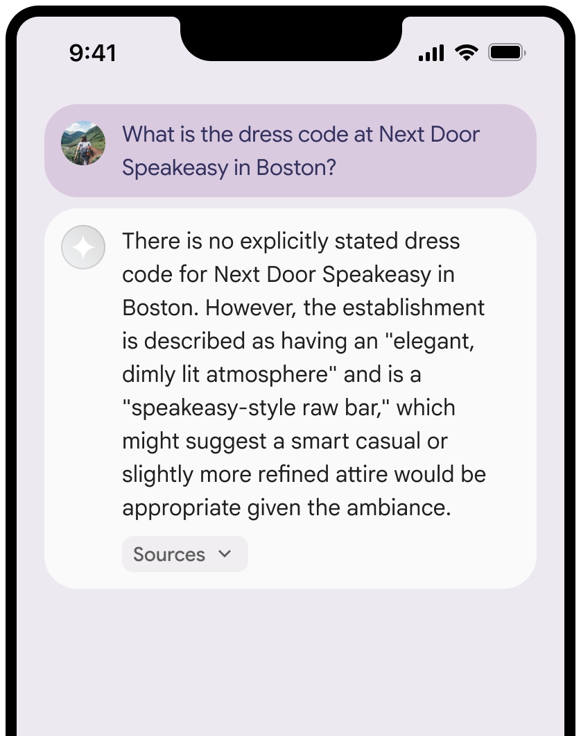
這些圖片顯示來源和 Google 地圖連結的最低顯示要求。
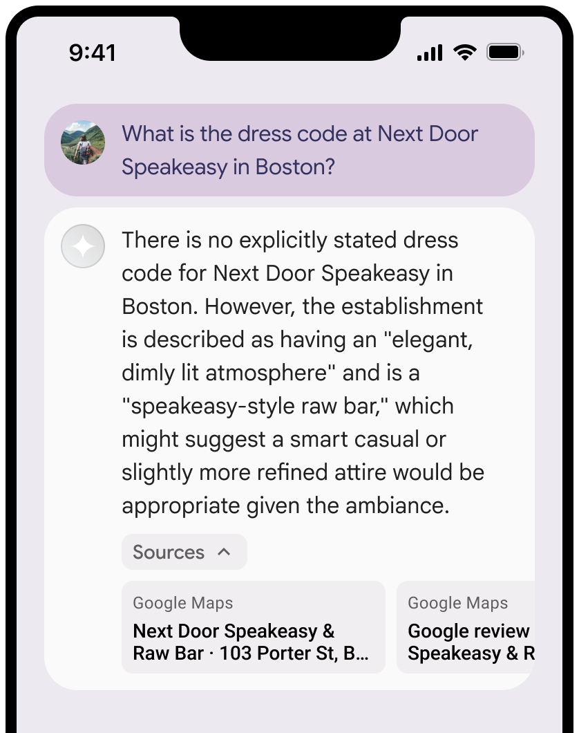
你可以收合來源檢視畫面。
選用:加入其他內容 (例如:) 來強化連結預覽畫面:
- Google 地圖 Favicon 會插入 Google 地圖文字出處之前。
- 來源網址 (
og:image) 中的相片。
如要進一步瞭解部分 Google 地圖資料供應商及其授權條款,請參閱 Google 地圖和 Google 地球法律聲明。
Google 地圖文字出處資訊規範
在文字中將來源歸給 Google 地圖時,請遵循下列規範:
- 請勿以任何方式修改「Google 地圖」文字:
- 請勿變更 Google 地圖的大小寫。
- 請勿將 Google 地圖換行顯示。
- 請勿將 Google 地圖本地化為其他語言。
- 使用 HTML 屬性 translate="no",防止瀏覽器翻譯 Google 地圖。
- 按照下表說明設定 Google 地圖文字樣式:
| 屬性 | 樣式 |
|---|---|
Font family |
Roboto。你可以選擇是否載入字型。 |
Fallback font family |
產品中已使用的任何 Sans Serif 內文,或「Sans-Serif」來叫用預設系統字型 |
Font style |
一般 |
Font weight |
400 |
Font color |
白色、黑色 (#1F1F1F) 或灰色 (#5E5E5E)。與背景維持無障礙 (4.5:1) 對比度。 |
Font size |
|
Spacing |
一般 |
CSS 範例
下列 CSS 會在白色或淺色背景上,以適當的排版樣式和顏色顯示 Google 地圖。
CSS
@import url('https://fonts.googleapis.com/css2?family=Roboto&display=swap');

.GMP-attribution {

font-family: Roboto, Sans-Serif;
font-style: normal;
font-weight: 400;
font-size: 1rem;
letter-spacing: normal;
white-space: nowrap;
color: #5e5e5e;
}
地點 ID 和評論 ID
Google 地圖資料包括地點 ID 和評論 ID。您可能會快取、儲存及匯出下列回覆資料:
placeIdreviewId
《利用 Google 地圖建立基準服務條款》的快取限制不適用。
禁止的活動和地域
利用 Google 地圖建立基準時,某些內容和活動會受到額外限制,以維護安全可靠的平台。除了《條款》中的使用限制外,您也同意不從事下列行為:
- 您不會將「運用 Google 地圖建立基準」功能用於高風險活動,包括緊急應變服務。
- 您不會在禁止地區發布或行銷應用程式,透過 Google 地圖提供 Grounding 服務。詳情請參閱「Google Maps Platform 禁止地域」一文。禁止發布內容的地區清單可能會不時更新。
最佳做法
- 提供使用者位置資訊:如要取得最相關的個人化回覆,請在知道使用者位置資訊時,務必在
googleMapsGrounding設定中加入user_location(經緯度)。 - 告知使用者:清楚告知使用者系統會使用 Google 地圖資料回答查詢,尤其是在啟用這項工具時。
- 監控延遲時間:如果是對話式應用程式,請確保有根據的回覆的 P95 延遲時間維持在可接受的門檻內,以維持流暢的使用者體驗。
- 在不需要時關閉:預設會關閉利用 Google 地圖建立基準的功能。只有在查詢有明確的地理位置脈絡時,才啟用這項功能 (
"tools": [{"googleMaps": {}}]),以提升效能並節省費用。
限制
- 適用地區:利用 Google 地圖建立基準的功能已在全球推出
- 支援的機型:請參閱「支援的機型」一節。
- 多模態輸入/輸出:目前「利用 Google 地圖建立基準」功能不支援文字以外的多模態輸入或輸出內容。
- 預設狀態:「利用 Google 地圖建立基準」工具預設為關閉。 您必須在 API 要求中明確啟用這項功能。
價格和頻率限制
利用 Google 地圖建立基準的定價會因模型生成方式而異:
- Gemini 3 和更新的模型:系統會針對模型決定執行的每項搜尋查詢向專案收費,所有 Gemini 3 和更新的模型每月共用 5,000 次免費要求,之後每 1,000 次搜尋查詢的費用為 $14 美元。單一搜尋提示 (您對模型發出的 API 要求) 可能會導致模型執行多項搜尋查詢,以找出必要資訊。這些查詢都會計為工具的付費使用次數。
- Gemini 2.5 和舊版模型:系統會根據搜尋提示向專案收費 (每 1,000 個基礎提示 $25 美元)。只有在提示成功傳回至少一個 Google 地圖錨定結果時,才會針對要求收費,無論模型在內部執行多少個別搜尋查詢來取得該結果,皆是如此。
「利用 Google 地圖建立基準」的配額通常與基礎 Gemini 模型的頻率限制一致。如需詳細的定價資訊,請參閱 Gemini API 定價頁面。
支援的模型
下列機型支援「利用 Google 地圖建立基準」:
| 模型 | 利用 Google 地圖建立基準 |
|---|---|
| Gemini 3.8 Flash | ✔️ |
| Gemini 3.6 Flash | ✔️ |
| Gemini 3.5 Flash-Lite | ✔️ |
| Gemini 3.1 Pro 預先發布版 | ✔️ |
| Gemini 3.1 Flash-Lite | ✔️ |
| Gemini 3 Flash 預先發布版 | ✔️ |
| Gemini 2.5 Pro | ✔️ |
| Gemini 2.5 Flash | ✔️ |
| Gemini 2.5 Flash-Lite | ✔️ |
支援的工具組合
您可以搭配使用「利用 Google 地圖建立基準」功能與其他內建工具,例如「以 Google 搜尋強化事實基礎」功能 (支援 Gemini 3.5 Flash-Lite 和後續版本),處理更複雜的使用情境。Gemini 3 模型也支援將這些內建工具與自訂工具 (函式呼叫) 結合使用。詳情請參閱「工具組合」頁面。
後續步驟
- 請參閱 Gemini API 教戰手冊中的「以 Google 搜尋強化事實基礎」一節。
- 瞭解其他可用工具。
- 如要進一步瞭解負責任的 AI 最佳做法和 Gemini API 的安全篩選器,請參閱安全設定指南。